


Story and photos by Chuck Graham
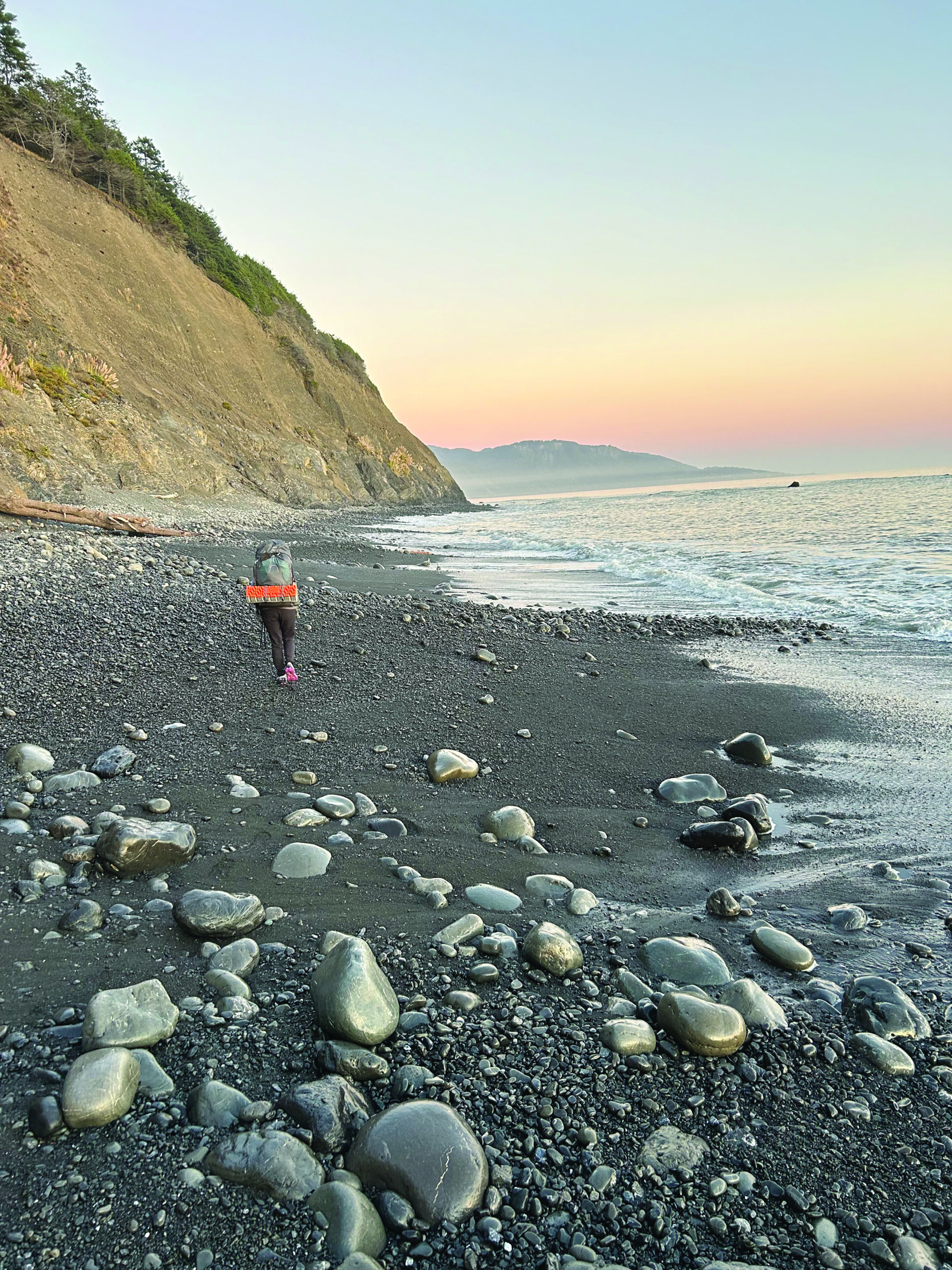
An hour after the late afternoon high tide had peaked, my girlfriend Holly and I made our four-mile dash along what is known as one of two “Impassable Sections” of the Lost Coast, in Northern California.
The classic, 25-mile-long southbound coastal route begins at the Mattole Campground and finishes at Shelter Cove. The roadless stretch of coastline in Mendocino and Humboldt counties is fortified with craggy rock outcroppings, gritty black sand beaches and the mighty King Range National Conservation Area, where a multitude of rushing creeks converge with thundering, unruly surf.
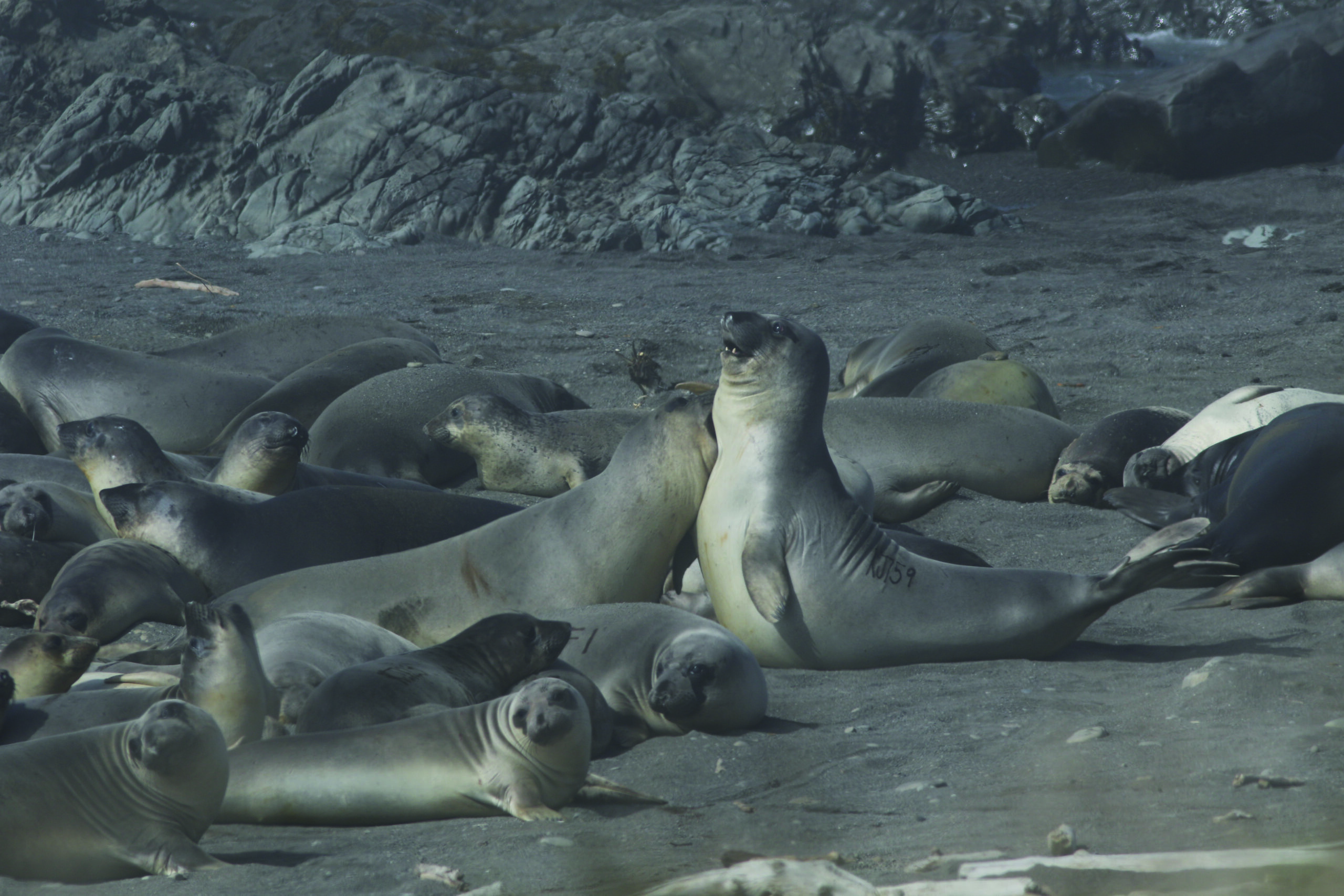
Raucous seals and sea lions haul out, breed, pup and bask along the wave-battered shoreline, enjoying very little disturbance along the remote Lost Coast. The beaches are also frequented by black bears and other wildlife that access the many clearwater creeks and densely forested, open book-shaped canyons of the King Range. Those runnels eventually spill beneath windswept marine terraces before reaching the coast. Yep, the Lost Coast is breathtaking on many levels.
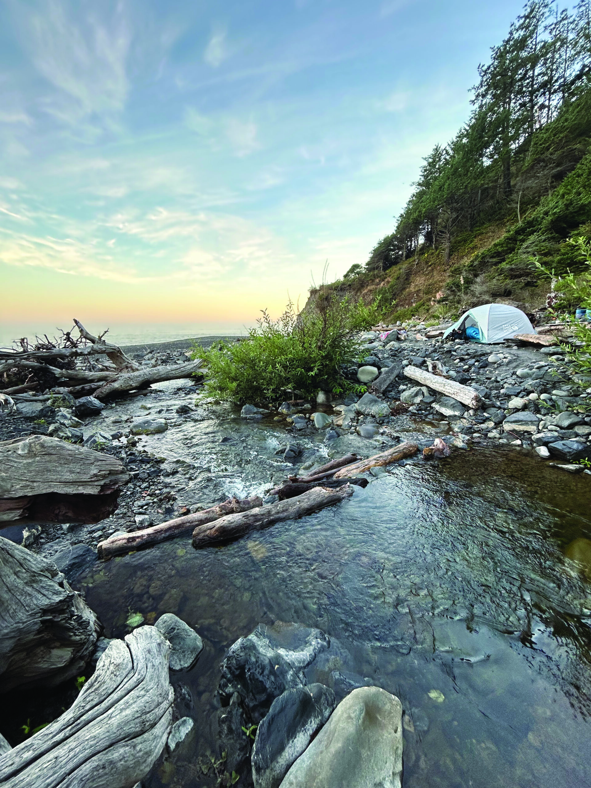
As the tide continued to ebb, there were still mad tidal surges sweeping up the beach. We navigated (and ran) beneath the eroding bluffs along boulder-strewn beaches before reaching Randall Creek at dusk. The melodious hydrology of the gushing creek and the outgoing tide was soothing to our senses, as we were greeted by a playful river otter. Apparently, river otters also love foraging in the inshore waters. It left the creek and dove directly into the coastal shallows, happy with its crab catch. It was one of many pleasant surprises revealed along the grandiose Lost Coast.
Lost Coast Logistics
The Lost Coast possesses several options for seaside solitude, but access into the stunning King Range is also easily attainable. There’s magic in the open ocean air trekking from the coast to just up above 4,000 feet. Up and down the California Coast are several mountain ranges offering a different perspective from sea level to lofty coastal summits, and the Lost Coast combined with hikes into the King Range is arguably the most epic.
However, don’t forget the southern Lost Coast. From Shelter Cove to Usal Beach and beyond are less-frequented trails requiring more bushwhacking and navigation, the Lost Coast living up to its name. Still, the classic route from Mattole Campground south to Shelter Cove is the most well-traveled track, and for good reason. Here’s a look into what’s required of backpackers and hikers searching for that memorable Lost Coast experience.
1. Permitting Process
Summer is going to be the most popular time to walk the Lost Coast, so get your permits early, at least six months in advance. Peak season is going to be May through September. To acquire a permit for the Lost Coast, go to www.recreation.gov. Permits can also be attained at the BLM Arcata Field Office, 707.825.2300, or the King Range Office in Whitethorn, 707.986.5400. Permits cost $6.
2. Getting There
Shuttle services are available for drop-offs and pickups for one-way hikes. Lost Coast Adventure Tours offers guided hikes and a shuttle. Call 707.986.9895 or 707.502.7514, or visit www.lostcoastadventures.com. Also, Mendo Insider Tours, 707.962.4131, www.mendoinsidertours.com.
3. Weather
There are a lot of variables to consider while experiencing the Lost Coast. Northern California is exposed to the elements and can fluctuate throughout the day. Winter is wet. The King Range averages 100 inches of rain per year. Spring is green, lush and beautiful, but it’s also windy. Typically, north/northwest winds howl down the coast, many days at gale force (although the wildflowers are surprisingly hardy). Summer will have lots of billowing, dewy fog. It can be cold and wet, and those overcast skies can persist for days on end. Fall is arguably the best time to visit the Lost Coast. Schools are back in session, and the calmest, mildest weather is late summer into early fall. Stay abreast of the weather with the National Oceanic Atmospheric Association at www.noaa.gov, and with Windy, www.windy.com.
4. Mind the Tides
Keep a tide chart handy. Many backpackers and day hikers have become trapped, even pinned against the bluffs and cliffs, because they didn’t gauge the incoming tides. From Sea Lion Gulch to Randall Creek is the first four-mile “Impassable” section. The second four-mile “Impassable” section is from Miller Flat to Gitchell Creek. At each section, it can be several hours before the tide turns and the impassable becomes passable.
5. Gear Up
If you’re backpacking the classic Mattole to Shelter Cove route, one thing you don’t need to carry is a lot of water — but keep a filter handy. There are 12 reliable creeks to collect water from. Even better, there’s great tasting water filtering through the many shale bluffs between all those creeks. Always keep a rain jacket handy. Not only because of rain, but the fog can be so moist, it will feel like it’s raining. Sunscreen, lip balm, hat, sunglasses are musts; a Crazy Creek chair is a nice addition. A small burner stove is essential.
A lot of the coastal route is on black sand beaches. A great way to hike is barefoot, but keep trail shoes or hiking boots handy for the low-lying marine terraces, cobbled shorelines and detouring into the King Range. Consider hiking poles for picking through loose cobble on some of the coastal routes. For wildlife viewing, consider a pair of binoculars. Being in such proximity to the ocean and the coastal range offers great biodiversity of flora and fauna. Bring a map. Wilderness Press, www.wildernesspress.com has a very detailed map of the Lost Coast.
6. Calories
Oatmeal with dehydrated fruit jumpstarts my day. Maybe it’s just me, but it seems like every year, dehydrated meals get better with more variety. And with plenty of creeks and natural seeps, there’s plenty of coves, beaches, creek-mouths and campsites to enjoy a meal. Beyond dehydrated meals, I enjoy dry cheese, salami and crackers with a dash of mustard. I don’t skimp on dark or hot chocolate. Dried mangos, Oberto’s bacon jerky, energy chews, fig bars and dates round out the menu.
7. Leave No Trace
There are no trash cans along the coastal route except at the Mattole Campground and at the Black Sands Beach parking lot at Shelter Cove. It’s pack in, pack out. Leave the Lost Coast cleaner than you found it. Having said that, there was little or no trash between Mattole Campground and Shelter Cove. As far as sanitation goes, bury all human waste at least six to eight inches deep and at least 200 feet from water sources. It can also be buried below the high tide line.
8. Keeping the Wild in the Wilderness
Black bears are the biggest concern. Bring a bear canister and sleep easy at night. Detailed black bear tracks are numerous on the black sand beaches. Raccoons can also be an issue. Tuck the canister somewhere in the flotsam of driftwood away from your campsite.
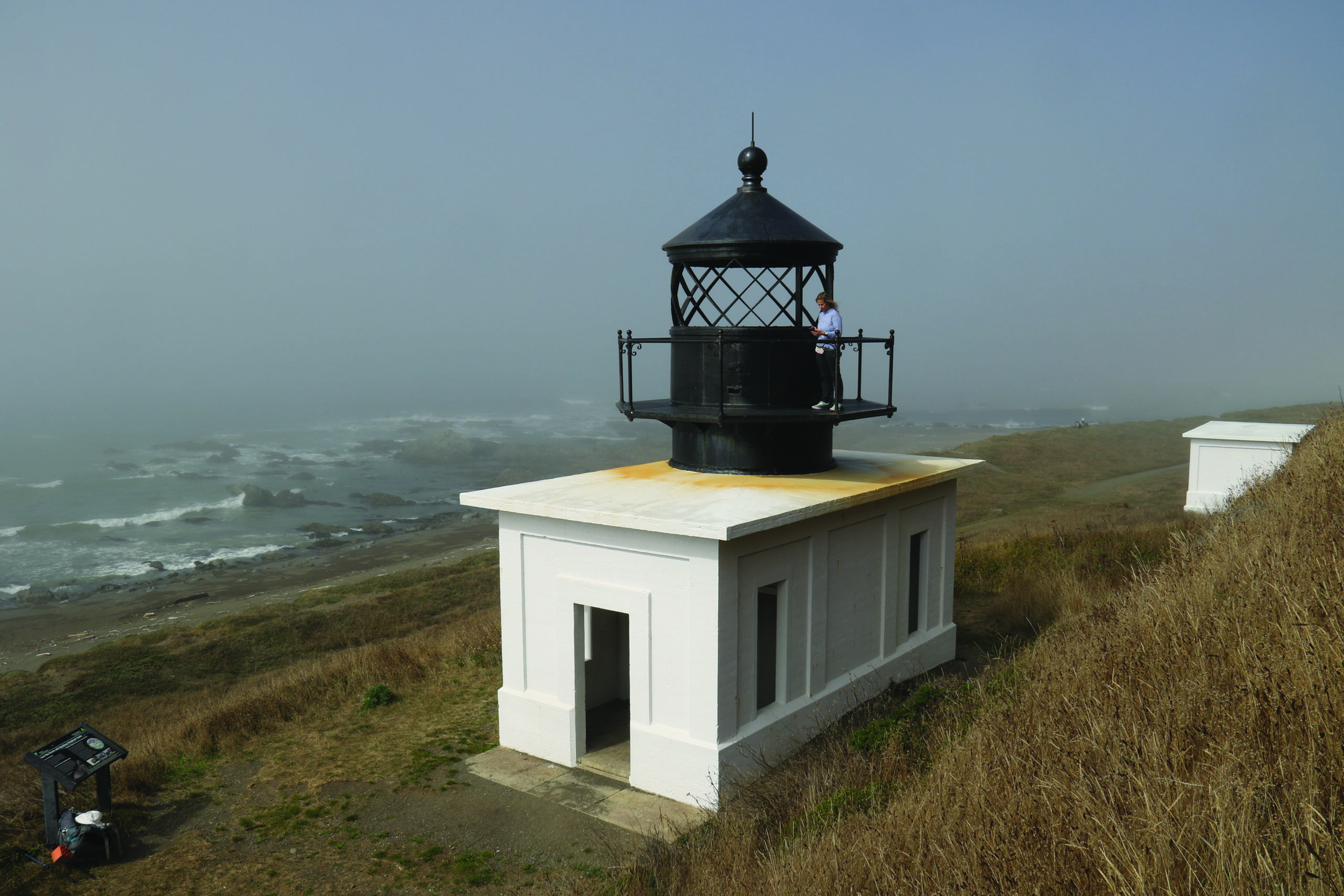
As long as food items stay safely secured, enjoy the abundant flora and fauna of the area. Hiking and backpacking the Lost Coast can potentially deliver great wildlife sightings. Between Mattole Campground and Randall Creek, expect to see spotted harbor seals at Windy Point, a growing northern elephant seal rookery just below the well-maintained but nonoperational Punta Gorda Lighthouse, and bellowing sea lions at the aptly named Sea Lion Gulch. Mule deer are regularly spotted, and with a little patience, bobcats can be seen at Big Flat. Turkey vultures, ospreys and golden eagles are seen patrolling the coastal skies. And if you’re lucky, a rambunctious river otter just might greet you on a lonely Lost Coast beach.